
JERVOIS PROJECT OVERVIEW | DEVELOPMENT & PERMITTING | OTHER PROSPECTS
Unca Creek
KGL considers the acquisition of exploration tenement EL28082, known as the Unca Creek Project, to have considerable strategic value. The tenement has almost trebled the size of KGL’s 100% owned Jervois Copper Project area from 37.9 km2 to 110.8km2. Unca Creek offers geological similarities to Jervois and is located in the highly prospective Bonya Metamorphics.

Figure 1 Topographic map of tenements

Figure 2 Aeromagetics for Jervois region
Although relatively under-explored, work undertaken by previous tenement holders including MIM, Normandy Poseidon and NRE has demonstrated the tenement’s exploration potential. This includes the northern strike extension of the sequence of rocks that host the Marshall-Reward deposits which represent a substantial part of KGLs current Resource at Jervois. As a result, the acquisition offers multiple walk-up drill targets.
Northern Prospects
At the northern edge of KGL’s existing Jervois Copper Project area, copper mineralisation at the Boundary prospect can be observed in outcrop extending on to the Unca Creek tenement. Reconnaissance mapping has located numerous malachite occurrences and prospective host units to the north of Boundary.
Soil and rock chip sampling undertaken by NRE has demonstrated a continuous trend of anomalous copper mineralisation with soil samples of up to 2080ppm and rock chip samples of up to 23% Cu. (Figure 3)
Aeromagnetic and IP data also show a continuous trend – the Reward/Morley trend - between Boundary and the Becana prospect then north to the Pioneer prospect and beyond to the northern boundary of the Unca Creek tenement. (Figure 4 & 5)
Becana Prospect
The Becana prospect is located 350m north of the Boundary prospect where KGL intersected 11m @ 0.72% Cu, 3.6g/t Ag from 63m in KJCD004 when following mineralised trends north of the Marshall- Reward copper deposit and the northern extension of the Reward/Morley trend.
Drilling by NRE on this mineralised trend at Becana intersected significant copper mineralisation including:
9m @ 2.3% Cu, 9.8g/t Ag from 144m (NRC011) including 2m at 8.1% Cu, 22.5g/t Ag, 0.11g/t Au from 148m
2m @ 1.2% Cu from 63m (NRC013)
Pioneer Prospect
The Pioneer prospect is 1.2km north of the Boundary prospect beyond Becana. Earlier drilling by MIM that included:
8m @ 1.08% Cu from 198m (J21)
This was followed up by NRE who drilled further north intersecting shallow copper mineralisation including:
8m @ 1.5% Cu from 39m (NRC001)
4m @ 1.1% Cu from 40m (NRC002)

Figure 3 Soils and Rockchip copper assays
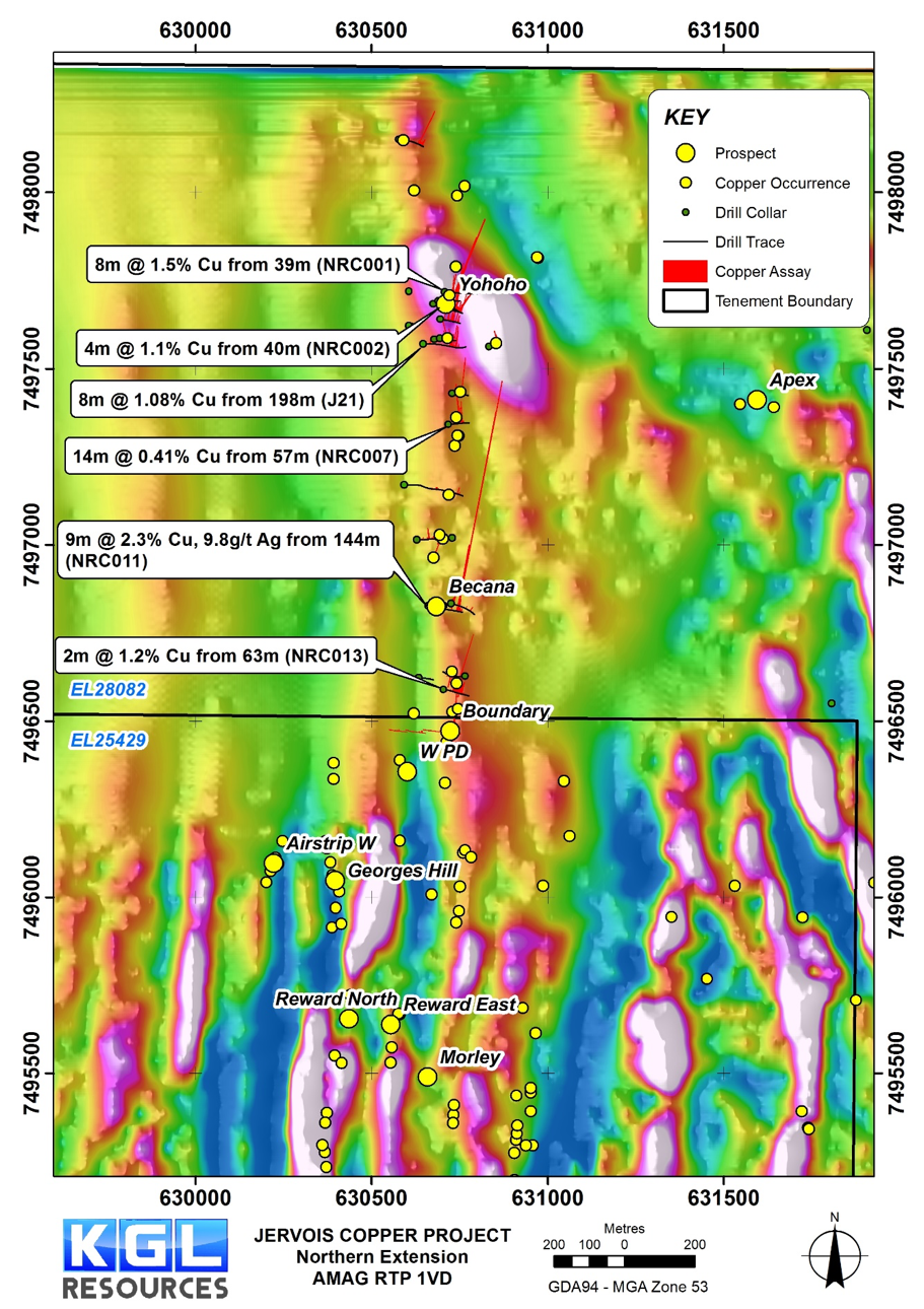
Figure 4 Airborne magnetics north of Reward deposit with known copper mineral occurrences
KGL reprocessed an IP survey conducted by MIM, and calculated 3D inversions of chargeability and resistivity. The results revealed a strong chargeability anomaly that extends from Boundary to Becana and further north to Pioneer (Figure 5).

Figure 5 IP Chargeability 100m depth slice
Between the Reward/Morley trend and Hamburger Hill there is the Apex prospect within a tightly folded fold closure. Union Corporation mapped a malachite occurrence within folded calcsilicate units that coincides with a weaker parallel chargeability trend to the east of the main anomaly that is coincident with the Apex target where outcropping copper mineralisation has been observed. This prospect has no previous drilling.
Hamburger Hill
Hamburger Hill is located 2.9km east of the Reward/Morley trend in a sedimentary/volcanic host sequence that resembles the Bellbird-Rockface area. Existing structural interpretations indicate that Hamburger Hill may be a folded repetition of the Reward/Morley trend. Previous wide-spaced (~200m) RC and diamond drilling by Normandy intersected copper-lead-zinc mineralisation hosted in calcsilicate rocks. Best intersections include:
7m @ 1.28% Cu, 0.65% Pb, 0.34% Zn from 158.6m (HHD-1A)
4.2m @ 1.17% Cu from 115.8m (HHD-3)

Figure 6 Hamburger Hill SAM Induced Polarisation highlighting the high chargeability zones
Reprocessing of the SAM data acquired by NRE has recovered the Total Field Magnetometric Induced Polarisation (TFMMIP) information that is showing a good chargeability anomaly coincident with known mineralisation and has outlined the northern extension to this anomaly that remains untested (Figure 6). The central TFMMIP anomaly is over 1 km in length.
Southern Prospects
There is further potential in the southern area of EL28082 where very little previous exploration has been undertaken. On the southern portion of the NRE tenement, directly south from the J-shaped Jervois Range there are four tungsten-copper prospects that are aligned to form an outer J-shaped trend (Big J trend). The tungsten-copper occurrences are hosted by a sedimentary sequence that includes calcsilicates and iron-rich sediments. CSIRO’s recently completed 3D geological model for Jervois raises the possibility that the outer J-shaped trend is a folded repetition of the host sequence at Jervois. This area could potentially host sulphide lenses.
Gravity survey
A detailed gravity survey was completed at the Jervois project in early 2016. Results of this survey have proved very effective at locating magnetite and garnet-altered rocks that are commonly proximal to mineralisation. Magnetite-garnet altered rocks are significantly denser than the unaltered country rocks and constitute a good gravity target. This is especially evident in areas such as Marshall, Reward and in the fold hinge zone at Rockface where the gravity response is significantly higher. The presence of high density sulphide minerals can make the gravity response even larger.
A gravity survey has been complete over the entire Unca Creek tenement. This has improved the understanding of the geology, and in combination with existing drilling results, previous geophysical surveys and structural mapping, defined and refined new and existing drill targets.

Figure 7 Residual Bouguer gravity of the Jervois and Unca Creek tenements. Gravity highs(red/white) are often associated with iron rich units and gravity lows (blue/green) are often associated with the more felsic units